País: España Ciudad: Madrid – 28003 Dirección: Calle General Ibáñez de Ibero 3
Actividad del «Atlas Didáctico» del IGN: «Realizar el croquis de un paisaje»
Descripción:
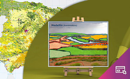
Vamos a realizar una actividad del «Atlas Didáctico» del IGN con el objeto de familiarizar al público general con este recurso educativo de libre acceso. La actividad elegida se denomina «Realizar el croquis de un paisaje» y pertenece al tema «Paisaje» del «Atlas Didáctico», formando parte del grupo temático «Estructura territorial».
Los croquis dibujados sobre una fotografía de paisaje son una herramienta didáctica que puede favorecer una observación detenida para identificar elementos y unidades del paisaje, facilitar el comentario e interpretación de una imagen de paisaje y desarrollar la capacidad de síntesis.
Permiten sintetizar ideas fundamentales y son resultado de un proceso de análisis e interpretación complejo. Son un instrumento útil para plasmar lo relevante y prescindir de información accesoria.
📌 ¿En qué consiste la actividad?
El reto consiste en elaborar un croquis sobre una fotografía de paisaje, identificando unidades y componentes del paisaje.
¿Te animas a interpretar un paisaje que conozcas dibujando un croquis?
Consulta las instrucciones para participar en esta actividad.
Principales objetivos:
- Aprender a analizar e interpretar un paisaje.
- Comprender el espacio geográfico desde una perspectiva sistémica.
- Educar la mirada geográfica hacia el aprecio del patrimonio paisajístico, la sostenibilidad y el respeto hacia el territorio.
| Organizadores: | Instituto Geográfico Nacional (IGN) – Recursos Educativos de Geografía. |
| Modalidad: | Online. |
| Tiempo estimado: | 1 hora. |
| Participación: | Actividad abierta desde el 4 al 6 de abril de 2025. |
Enlaces de interés:
- Visita Educa IGN para conocer más recursos educativos de geografía.
- Descubre el territorio: Dibujar un mapa
ACTIVITY FROM THE “DIDACTIC ATLAS” OF THE IGN: “CREATE A SKETCH OF A LANDSCAPE”
Description:
We are going to carry out an activity from the “Didactic Atlas” of the IGN with the aim of familiarizing the general public with this freely accessible educational resource. The chosen activity is called “Create a sketch of a landscape” and belongs to the “Landscape” theme of the “Didactic Atlas,” forming part of the thematic group “Territorial Structure.”
Sketches drawn over a landscape photograph are a didactic tool that can promote careful observation to identify elements and units of the landscape, facilitate the commentary and interpretation of a landscape image, and develop the capacity for synthesis.
They allow for the synthesis of fundamental ideas and are the result of a complex process of analysis and interpretation. They are a useful instrument for capturing what is relevant and discarding accessory information.
📌 What does the activity consist of?
The challenge consists of creating a sketch over a landscape photograph, identifying units and components of the landscape.
Do you feel like interpreting a landscape you know by drawing a sketch?
Check the instructions to participate in this activity.
Main objetives:
- Learn to analyze and interpret a landscape.
- Understand the geographical space from a systemic perspective.
- Educate the geographical view towards the appreciation of landscape heritage, sustainability, and respect for the territory.
| Organizers: | Instituto Geográfico Nacional (IGN) – Educational Resources of Geography. |
| Modaliity: | Online. |
| Expected duration: | 1 hour. |
| Participation: | Activity open from April 4th to April 6th, 2025. |
Links of interest:
- Visit Educa IGN to learn more about educational geography resources.
- Discover the territory: Drawing a map
GeoNight code: