Country: Lietuva – Lithuania – City: Žagarė – Address: Start from Malūno street 1, Žagarė, Joniškis district LT-84331
Night hiking “Geo – GRAPH” in Žagarė
Description:
During the night hiking trip, we will go on a journey of discovery where we will visit the most geographically important objects in Žagarė, which are also inseparable from the culture of manors of Old and New Žagarė.
Main objectives:
The main objective of the night hiking trail in Žagarė – to visit the most important geographical sites in Žagarė Regional Park, which are also closely related to the history of the town and the manor, and to present them to the participants of the walk.
Event language: Lithuanian
The event will be: “Live” in presence
Link (for online events): it will be displayed here as soon as possible
Reference person: Modesta Bielskienė – Role or function: Administrator of Visitors’ center of Žagarė Regional Park – Reference organization: Directorate of Žemaitija Protected Areas
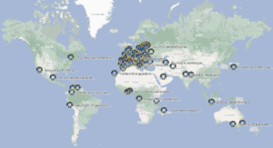
Those who organize are: Directorate of Žemaitija Protected Areas
Estimated starting time (local time): 7:00:00 PM
Expected duration: around 3 hours
Event program: it will be displayed here as soon as possible
GeoNight code: